


Winter storm 'Athena' heads for the Catskills, with hundreds still out of power
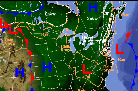
Above: Detail from a National Weather Service weather forecast map issued at 3:53 am today. Source: NWS Binghamton website.
Forecasters are tracking a nor'easter that looks likely to dump snow and sleet across a wide swath of the northeastern U.S. starting this afternoon, with up to 8 inches expected in the high peaks of the Catskills.
In a blog post published today, the Weather Channel explains why they have taken it upon themselves to name the storm "Athena":
...without Sandy, we may not have named this storm. However, one of our main reasons for naming events is societal impact. With so many people still under recovery efforts -- even well inland -- the combination of heavy, wet snow and wind prompted the decision to name this storm. The decision to name was based on a trend in models toward a colder pattern with additional snowfall along the Northeast Coast.


 On Wednesday afternoon, I asked a friend how he was doing in the wake of Hurricane Sandy. We joked that Sullivan County was on the verge of becoming a cold, wet version of