


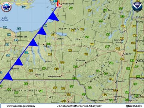
Above: Temperatures around upstate New York around 8 a.m. this morning, showing a cold front moving east across the region. The National Weather Service in Albany writes: "Current 8 a.m. temperature in Albany is 63 degrees while behind the cold front in Buffalo, NY, it is 33 degrees with a rain/snow mix."
Watch out for April showers -- and a few bouts of sleet and snow. After a few days of sunshine and temperatures in the 70s, the Catskills region is now bracing for the return of wintry weather as a cold front moves in from the west.
In the western Catskills, Delaware and Sullivan counties are under flood watch until late Tuesday evening, with an inch to an inch and a half of rain expected to fall in a short time period before plunging temperatures shift the precipitation over to sleet and snow. Large rivers are not expected to flood, but there may be areas of flash flooding in small creeks, low-lying roads and spots with poor drainage.
Hudson Valley Weather forecasts a dramatic temperature drop across the Catskills and Hudson Valley, starting this afternoon:
Temps will drop some 30-40 degrees by tonight causing and rain showers to end as snow showers and sleet tonight with accumulations of an inch or two possible across the Catskills with a dusting possible across some parts of the lower elevations.
Watch for slippery conditions and flooding on the roads tonight, and if you see flooding in your area, let us know at [email protected].


