


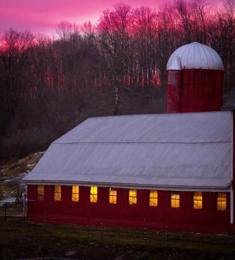
Above: It wasn't a white Christmas this year in the Catskills. Photo of a Delaware County dairy farm on Christmas Eve this year by Mark Zilberman, via the Watershed Post Flickr Pool.
After an oddly snow-less winter so far, Mother Nature is going to make up for it tonight. The National Weather Service has issued a winter weather advisory for the entire Catskills region warning of a storm that will roll in this evening and dump up to 6 inches of snow on high elevations. Wet stuff will begin to fall around 8pm, and will last until morning.
Here are the warnings:
For Ulster, Schoharie and Greene counties:
Winter Weather Advisory In Effect From Midnight Tonight To Noon EST Thursday... The National Weather Service In Albany Has Issued A Winter Weather Advisory For Snow And Freezing Rain...Which Is In Effect From Midnight Tonight To Noon EST Thursday. * Locations...Western New England...And All Of Eastern New York Excluding The Southern Adirondacks. * Hazard Types...Snow...Sleet And Freezing Rain. * Accumulations...1 To 6 Inches Of Snow Accumulation With Up To Two Tenths Of An Inch Of Ice Accretion. * Timing...Midnight Tonight Into Thursday Morning. * Impacts...Hazardous Travel Conditions. * Winds...Northeast 5 To 15 Mph With Gusts Up To 25 Mph. * Temperatures...Rising From The Mid 20S And Lower 30S Tonight Into The Mid To Upper 30S Late Thursday Morning.
For Sullivan and Delaware counties:
.Mix Of Snow And Sleet Will Arrive Tonight... ...Winter Weather Advisory In Effect From 8 PM This Evening To 11 AM EST Thursday... The National Weather Service In Binghamton Has Issued A Winter Weather Advisory For Snow, Sleet, And Spotty Freezing Rain...Which Is In Effect From 8 PM This Evening To 11 AM EST Thursday. * Locations...Mainly East Of Interstate 81. * Hazards...Snow, Sleet, And A Brief Period Of Freezing Rain Early Thursday. * Accumulations...Most Areas Will Receive 1 To 2 Inches Of Snow And Sleet, With High Elevations In The Catskills Region Receiving 2 To 4 Inches Of Snow. The Snow Will Melt Quickly When Rain Arrives Late Morning. * Timing...Mixed Precipitation Will Spread Across The Region From West To East Between 8 PM And 11 PM, And Continue Overnight. * Temperatures...Between 30 And 33 Degrees, Rising Into The Mid 30S By Late Thursday Morning. * Winds...East At 7 To 12 Mph. * Impacts...Snow, Sleet, And Freezing Rain Will Lead To Slow Travel And Slippery Conditions.


