


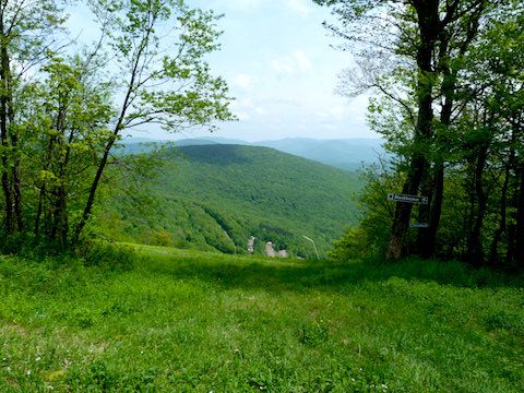
Above: Plattekill Mountain from above in summer. Photo by Alan Via.
Few hikers think about the Catskills’ four ski areas during warm weather, but these lightly-used mountains have some great foot trails for summertime adventurers.
Windham Mountain in Greene County, Belleayre Mountain Ski Center in Ulster County and Plattekill Mountain in Delaware County all welcome summer hikers and mountain bikers. Hunter Mountain has a ski lift that allows hikers to climb a trail to a fire tower on its summit.
All four ski mountains boast multiple hiking routes of varying steepness, from double black diamond ski trails to gentle bunny slopes. Hikers looking for easier trails might find the dirt or grass summit service roads an accommodating alternative.
The sunny ski trails usually are overgrown with tall grass by midsummer, but they’re often bordered by a variety of wildflowers. Bring your binoculars, as those open meadows are attractive to multiple bird species.
If you walk quietly, you may see deer or bears with their young feeding early or late in the day.
While most heavily wooded Catskills hiking trails offer only occasional views, on the region’s ski trails you can turn around in most places and see a sweeping view.
Also, Windham, Belleayre and Plattekill are fantastic places to take a dog along on your hike. You’ll seldom run into other hikers and don’t have to be concerned about leashes, your dog bothering hikers or getting into altercations with other dogs.
A word of warning: Be alert for mountain bikers. Although they generally prefer the steeper trails, be alert to the possibility of bikes sharing your route.
Hiking Cave Mountain and West Cave at Windham Mountain
Above: Cave Mountain at Windham Mountain Ski Center. Photo by Alan Via.
Windham Mountain is just off Route 23 in the Greene County town of Windham. Park in the large lot directly in front of the main ski center building. The ski center refers to the mountains that surround it as the East and West Peaks, but they have been known for decades as Cave Mountain (3,100 feet) and West Cave (3,040 feet).
Trails to both mountains begin immediately behind the main building. You can select ski trails or summit access roads. Some hikers do a loop, but until a new trail opens between the summits in 2017, the old road between them is overgrown in places.
My favorite trail up or down Cave Mountain is called “The Wanderer.” It “wanders” over the slopes, never steep but always scenic.
The ski tram terminates at the top of Cave Mountain, and the carpeted cement base under the lift tower is the perfect place for lunch, views, photography and relaxation after the 1,350-foot ascent.
Trail map: http://www.windhammountain.com/content/uploads/2015/12/BikeParkTrailMap2016.pdf
Hiking Belleayre Mountain at Belleayre Mountain Ski Center

Above: Heading down from the summit of Belleayre Mountain. Photo by Alan Via.
Belleayre Ski area is on County Road 49A, which is located off of Route 28 in the Ulster County hamlet of Highmount.
Belleayre has ski runs all over the mountainside. You can select trails near the base of the mountain or park in the lot at Overlook Lodge, which is located at 2,500 feet.
As with all ski areas, the shortest routes are the steepest. A great hike starts at Overlook Lodge and ascends a dirt and grass summit access trail. In winter, it’s known as Discovery Way and Cathedral Brook. The trail is never steep and offers regular views. As it reaches the summit ridge, the trail becomes a grassy delight bordered by wildflowers and ferns.
As you come out into the open near Sunset Lodge, there are great views that take in many of the Catskills’ 100 highest summits. The 3,420-foot summit is located a few scenic minutes uphill from Sunset Lodge.
After photography and lunch, follow the Deer Run ski trail back to Overlook Lodge.
The loop is three-and-a-half miles long with 900-foot ascent. You can add mileage and another 500 feet of climbing if you start from the Belleayre base lodge.
Trail map: http://www.belleayre.com/summer/hiking
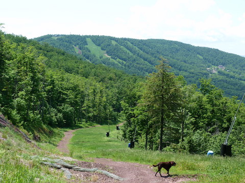
Hiking North Plattekill and Plattekill Mountain

Above: Hiking a ski trail at Plattekill Mountain. Photo by Alan Via.
Plattekill Mountain is at the end of Lower Meeker Hollow Rd., located off of Route 30 in the Delaware County town of Roxbury. This small, friendly ski center offers hiking, biking and geocaching fun in a more undeveloped area of the Catskills.
You can hike ski trails or graded summit roads up the 3,340-foot North Plattekill peak and its slightly shorter sister, 3,202-foot Plattekill Mountain. The base lodge is located in a twin-sided bowl under both summits at 2,265 feet, so expect steep climbing unless you hike up one of the summit access road or trails.
Trail map: http://www.plattekill.com/mountain-info/biking-trail-map
Hiking Hunter Mountain
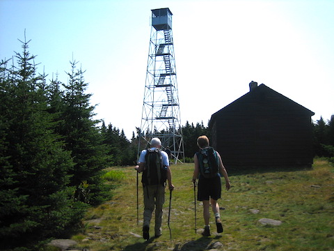
Above: The Hunter Mountain Fire Tower. Photo by Alan Via.
Hunter Mountain is located on Route 23A in the Greene County village of Hunter and offers an interesting option for summer hikers. The 4,040-foot summit is the second highest in the Catskills, and hikers can ride the Scenic Skyride to the top of the iconic 3,200-foot Colonel’s Chair, a ridge visible from many locations along the highway below.
From the top of the ski lift, it’s a four-mile roundtrip hike to the summit on a rugged wooded trail that gains almost 1,000 feet as it climbs. Although the trail doesn’t offer views, the summit fire tower does, with spectacular vistas in all directions.
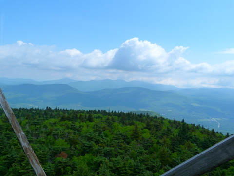
Above: The view from the Hunter Mountain Fire Tower. Photo by Alan Via.
If you time your visit for a warm-weather weekend, the fire tower cab is open and staffed by volunteers who can point out the peaks and sights and answer questions.
Hikers should budget an average of four hours for the round trip from the lift, and bring water, snacks and footwear suitable for a mountain trail. Hunter’s height, location, and fire tower offer some of the best views in the Catskills.
Skyride Details: http://www.huntermtn.com/summer/skyride/
Alan Via is a frequent contributor to the Watershed Post. He’s the author of “The Catskill 67 – A Hiker’s Guide to the Catskill 100 Highest Peaks under 3,500’,” where you can find additional hike details about the ski area peaks and other Catskill mountains.


