


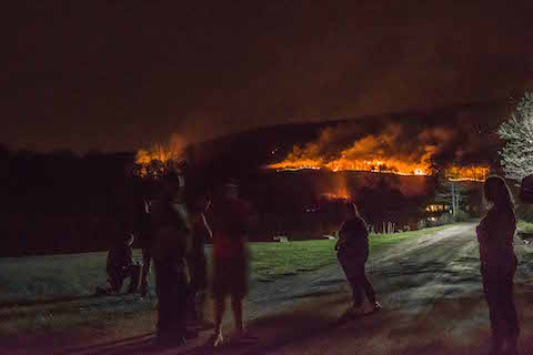
Above: A view of the Shawangunk brush fire looking south from the Summitville turn on Route 209 outside the Ulster County town of Ellenville at close to midnight on Tuesday, May 5. Photo by Michael Wentland.
A massive forest fire that began on Sunday, May 3 has burned through over 2,000 acres of forested lands in Sullivan and Ulster counties this week, prompting the evacuation of 30 homes and a statewide emergency response.
Forest rangers, firefighters, first responders, police and state emergency operation officials have fought the blaze, which is concentrated in the Roosa Gap and Shawangunk Ridge State Forests around Route 52 in Ellenville.
Above: A small crowd of onlookers watches the brush fire in the Shawangunks from Thornton Road in Wurtsboro, which overlooks the Shawangunk Ridge State Forest, on May 5. Photo by Michael Wentland.
Volunteer firefighters from as far away as Broome, Schoharie, Delaware and Greene counties have travelled to the area to fight the fire, based out of a staging area at the Kimble Hose Company in Ellenville. On Monday, May 4, the Ulster County Sheriff's Office ordered mandatory evacuations of 30 homes in the Ulster County hamlet of Cragsmoor, along Route 52. The evacuees were able to return to their homes the next day.
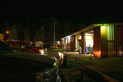
Above: The command post at Kimble Hose Company in Ellenville. Photo by Michael Wentland.
On Tuesday, May 5, Gov. Andrew Cuomo made the blaze a state concern, activating the state’s Fire Operations Center and mustering state resources to fight the fire, including a “Fire Boss” air tanker fixed-wing airplane that can scoop up to 800 gallons of water from a water body while flying and then dump in on a fire. Eyewitnesses tell the Watershed Post that that airplane was spotted scooping water from Lake Minnewaska on Tuesday.
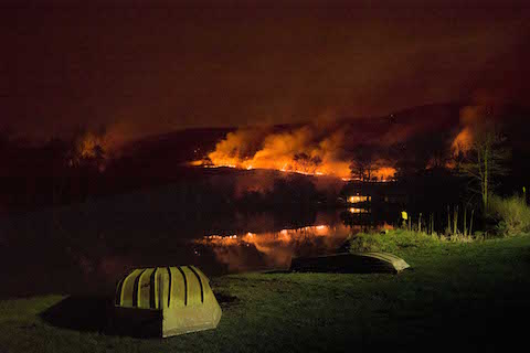
Above: The wildfire in the Shawangunks viewed from a pond on Thornton Road in Wurtsboro on May 5. Photo by Michael Wentland.
Four helicopters — two from the State Police and two UH-60 Blackhawk helicopters from the Division of Military and Naval Affairs -- are also dumping water on the fire, using so-called “Bambi buckets."
On Tuesday night, police kept tight control over access to the fire along Route 52 in Wawarsing, which has been closed to traffic since Monday and will remain closed through Wednesday night.
About ten minutes outside of Ellenville on Route 209, the edge of fire could be seen smoldering on a hillside and along the road. At the Kimble Hose Company, officials with the Division of Homeland Security and Emergency Services Offices coordinated and deployed first responders late into the night.
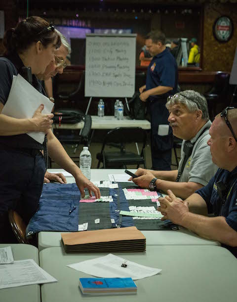
Above: Officials coordinate the emergency response at the Kimble Hose Company in Ellenville on May 5. Photo by Michael Wentland.
The cause of the fire hasn’t been formally announced, but the Times Herald-Record has reported that unnamed officials say the fire was caused by a homeowner burning brush in the town of Mamakating. It is illegal to burn brush in Mamakating year-round without a permit, and violators are subject to criminal and civil penalties.
Wendy Rosenbach, a spokesperson for the New York State Department of Environmental Conservation, which oversees the state’s brush burning laws, said yesterday that the cause of the Shawangunk wildfire is under investigation, and that no information is being released about whether a permit was issued for brush burning in Mamakating the day the fire began.
At 2 p.m. on May 6, a DEC official told the Watershed Post that 76 percent of the fire is contained, and that the number of acres consumed by the blaze is up to 2,617. Today, 93 volunteers are battling the fire, coordinated by a team of DEC forest rangers, the official said.
At 6 p.m., Ulster County Executive Mike Hein issued a statement saying that the wildfire was 90 percent contained, and that Route 52 has been reopened:
The Ulster County Fire Coordinator’s Office has reported that Route 52 between Old Plank Road and Cragsmoor Road in the Walker Valley/Cragsmoor area is now open to traffic. The area is still considered an active fire scene and firefighting operations will continue in the immediate vicinity. The public is asked to be aware of fire apparatus and personnel and is advised to use caution while traveling in the surrounding areas as smoke and weather conditions may change quickly. The wildfire has now been 90% contained.
Photographer Michael Wentland contributed to this report.
Correction: The photograph on the top story of this article was taken at the Summitville turn on Route 209, not the Summerville turn.


