


Sandbags outside Ricciardella's Restaurant this morning in Phoenicia. Photo by Aaron Bennett.
After the dire warnings of the past two days, the flooding isn't as bad as expected.
Ulster County Emergency Communications Director Arthur Snyder emailed at 12:30 to report that the worst for Ulster County was over:
Good afternoon The high end of the rainfall total was Phoenicia at 4.95", 3.94" in Woodstock, 3.82" in Bearsville and 3.72" at Slide Mountain.
The Upper Esopus crested at 15.8' at 5:15 this morning (4.8' above flood stage), the Lower Esopus crested at 23.05' at Mt Marion at 9 AM (3' above flood stage). The Rondout appears to have crested at about 11 AM at 21.4' (almost 3 1/2' above flood stage. The Wallkill is at 12.64' and rising (flood stage is 13'). Flood warnings remain in effect.
From 6 PM last evening until noon today, the fire service has pumper over 230 cellars throughout Ulster County.
There were eight separate rescues from vehicles of people who tried to drive through flooded roadways.
Evacuations occurred in parts of Shandaken, Saugerties, Town of Kingston and Woodstock. Ad hoc shelter were established at Belleayre Ski Center, Saugerties Sr Citizens Center and the Sawkill Firehouse.
States of Emergency have been declared in the Town of Kingston and the Town of Shandaken.
There are currently about 30 roads (or portions thereof closed). This is declining hour by hour as waters recede and roads are inspected by highway personnel.
Damage assessments forms have been faxed to all highway departments and all chief elected officials. Please complete these for significant damages.
The Wallkill is not anticipated to rise more than another foot or so, roads are re-opening and residents are returning to clean up their homes. Unless things change dramatically, this will be the final update for this storm. Thank you to everyone for a job well done.
We "have dodged a flooding bullet," Michael Koegel told us via phone earlier today, from his Mama's Boy restaurant on Main Street Phoenicia. In New Paltz, the Wallkill River flooded Rte. 299 and Springtown Rd. in New Paltz -- see photos at the Times Herald-Record.
In Delaware County, a National Weather Service flood warning is still in effect as of 2pm:
The National Weather Service In Binghamton Has Issued A * Flood Warning For A Portion Of The West Branch Delaware River...And Adjacent Small Streams... Central Delaware County... * Until 215 PM EST Friday... * At 813 AM EST...River Gauges Indicated That Water Levels Had Risen Over Flood Stage Just Above Delhi...Along The West Branch Of The Delaware. Although Heavy Rainfall Has Ended...Local Runoff Continues...Both From Earlier Rainfall And Snowmelt. Smaller Tributaries In The Vicinity Will Also Likely Experience High Water Levels. * Some Locations That May Experience Flooding Include Delhi...East Delhi...And Hamden.
One person in Delhi reported this morning that Legion Field was partially covered with water, and overflow on the Fowler Finch Dam in Sidney prompted the town supervisor to declare an emergency area immediately surrounding the dam. But other than that, things seem to be pretty quiet out there.
We took a tour along Rte. 28 this morning and again this afternoon to survey the floodwaters. As we passed Phoenicia at 7am, we saw the Esopus Creek just touching the bottom of the Bridge St. bridge. By 12:30, however, the waters had fallen somewhat. Here's the view from the Main St. bridge towards the Esopus at that time: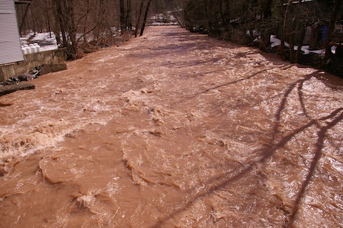
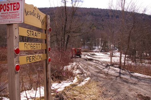
In Middetown along Rte. 28, a tributary of the East Branch of the Delaware had washed out Meade Hill Road, a dirt road, in three places:
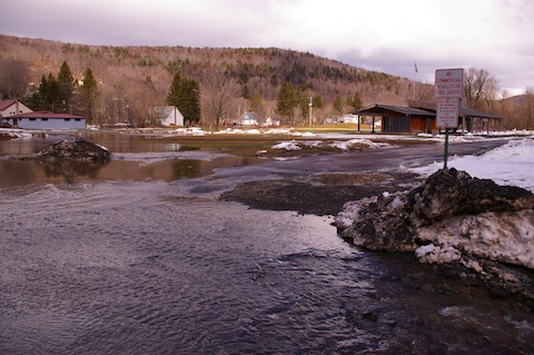
And in Margaretville, the park behind the Freshtown was partially covered with water:
For more flood reports from today's floods, click here.


