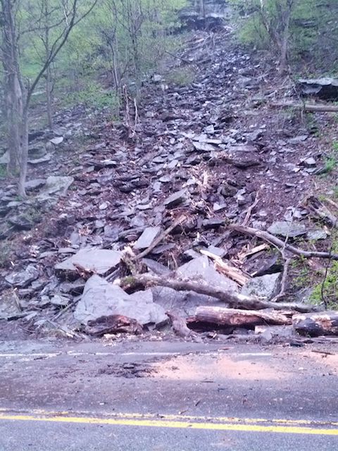
Above: A landslide on a steep bank overlooking Route 42 in Lexington. Photo by Lissa Harris.
A stretch of Route 42 in Greene County was shut down on Thursday morning after a mudslide, and remains closed. Traffic has been shut down from Spruceton Road in Lexington to the Ulster County line, and drivers are being detoured around the area via Route 23A and Route 214.
The mudslide was discovered around 9:40 a.m., according to Bryan Viggiani, a spokesperson for the New York State Department of Transportation (DOT).
On Thursday afternoon, Viggiani said the DOT had staff at the site of the mudslide assessing the situation, and more were en route to the site. It is unclear when the road will be re-opened, he said.
"There's a mudslide and there's debris on the road," he said. "Until we can make an assessment, all we can tell you is that the road's closed, and we don't know for how long."
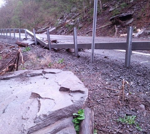
At the scene of the landslide, a trail of large rocks, trees and rubble could be seen on the road's steep western bank, leading down from a rocky ledge high above the roadway. A large rock several feet across (pictured below) lay on the road's opposite bank, the eastern guardrail smashed and bent.
By around 5 p.m. Thursday, crews had departed and debris had been cleared from the road, but the road remained closed to traffic. Officials are unsure whether the area around the landslide may be unstable.
Heavy rain is expected to fall Friday, which may complicate the situation on Route 42. A flood watch has been issued for Western Greene and Ulster counties, in effect Friday afternoon through Saturday morning.
On average, 718 vehicles pass through the closed stretch of Route 42 per day, Viggiani said.
Route 42 in Lexington was heavily damaged by flooding and landslides during the Irene floods in 2011. The road was closed for six months after the flooding, reopening in February of 2012.
Update, Friday, May 16: The road remains closed while DOT engineers and geologists assess the area of the landslide, according to Viggiani, who said that the agency was working to reopen the road as quickly as possible.
"After each rock fall, NYSDOT's Geology Office responses to the site to determine if there is anything we can do to provide more stability to the formation and/or protection from rocks, mud, etc. encountering the roadway," Viggiani wrote in an email.
"Our absolute Number One priority is the safety of the traveling public. Please understand that we are concerned about the stability of the slope, particularly in light of the predicted additional rain. Motorists should not try to drive past the road closure points."
The area where the landslide occurred is close to a spot where extensive repairs were made after the Irene floods, but it is not in the exact same location.
Local officials are also worried about erosion at another spot on Route 42 about three miles east of the landslide, at the intersection with Beech Ridge Road North, according to a report in the Daily Mail.
Update, Tuesday, May 20: The DOT has announced that Route 42 will be reopened by the morning of Wednesday, May 21.
Below: A Google Map showing the section of the road that is closed.
Below: A large rock that appears to have slid down from a steep bank, crossed the road and smashed through a guard rail. Photo by Lissa Harris.