


Above: Video of damage at the Frost Valley YMCA, created by stranded YMCA staffers up the blocked-off Oliverea Road.
Anyone with updates, please post them on our Hurricane Irene Catskills live blog.
4am, Wednesday, 8/31/11:
Frost Valley YMCA, the Full Moon Resort, and a bunch of other folks up Oliverea Road are still stranded, although emergency responders say that they've made contact with 95% of them. Rob Stanley says that Frost Valley YMCA people have plans to leave today through Denning. Melissa Pauls from the Frost Valley YMCA emailed us this report of how they're doing:
Hurricane Irene Relief Needed at Frost Valley YMCA
Claryville, NY—On August 28, 2011, Hurricane Irene caused an overwhelming amount of destruction to Frost Valley YMCA and the water wrecked havoc on our camp and conference center. Currently there is no access by road to Frost Valley and we do not have an estimated timeline on when the road will be accessible. We will communicate when we know more.
Entire roads and bridges were washed away. One of our historic buildings, Pigeon Lodge, was engulfed by water and shattered beyond repair. Trees were down and buildings filled with water. We have started to clean up but it will be many weeks before we will see the full effects of this storm.
As the staff work to get the camp up and running, the Executive Leadership Team and the Board of Directors are focused on the many financial steps that must be addressed to start the rebuilding of Frost Valley. We are seeking donations through our website of www.frostvalley.org/relieffund. We will be announcing other help needed as we get a better idea of the damage.
For continuous coverage, please follow us on Twitter: twitter.com/frostvalley or on Facebook: facebook.com/frostvalley. For questions about programs, please check our website or email [email protected].
Established in 1901 as one of the nation's first summer camps, Frost Valley YMCA now provides four seasons of outdoor, experiential and educational opportunities. Frost Valley YMCA is a 6,000 acre residential camping, environmental education, and conference center located in the heart of the "forever wild" Catskill Mountain Preserve and serves over 40,000 visitors per year.
I spoke with Shandaken EMS stalwart Rich Muellerleile and Shandaken supervisor Rob Stanley last night. Here's the transcript of our conversation:
Rich Muellerleile Shandaken EMS:
Everybody seems to be doing ok, we're doing secondary searches now of Oliverea. Recommending that everybody evacuate. We have made it past the ravine..haven't really had a whole lot of officials up there yet. Mikey Ford, an incredible citizen up there, blazed a trail on an ATV. He seriously got up there, made contact, and everybody is doing ok.
The biggest thing people up there need to realize: if they need oxygen, medical issues, it could be a very long time before utilities go back on.
Elderly people. We've made contact with a whole lot of people up there -- the number that was mentioned was 95%. There's always going to be one or two tucked way back in the woods up there.
Big Indian Trail/ Big Indian Club -- We've been up there.
All the way back to Winnisook Lake.
Rob Stanley, Shandaken Town Supervisor:
We got into Winnisook Lake..hoping to have a temporary bridge up on Hatchery Hollow road tomorrow. up temporary bridge tomorrow.
No visiting traffic, local traffic only. We've all worked in coordination together. A gentleman, Mike Ford, of Oliverea, travelled by AVT...Pete Estes, constructed a makeshift dirt road around the ravine near Winnisook Lake, again, confirmed Winnisook Lake intact, all residents OK. Our understanding that they may be able to get out through the other side.
Frost Valley should be leaving by 10am tomorrow.
If anybody needs oxygen, please notify us here at the Shandaken Command Center: 845-688-7315.
Again, we ask no visitors for Shandaken. We're doing our best to reclaim the roads...still now power for most of the area.
Phoenicia United Methodist Church: They are accepting clothing donation and clean and usable goods, for people who have lost stuff in the flood. Open T, Th, Sat 9am to 2pm, 27 Church Street Phoenicia. Contact: Linda Arnold. 688-7858. Please no donations left outside the church. Again, clean and usable. Clothing drop-box near Shandaken fire house. Lastly, know that the feds have been contacted. We have representatives coming tomorrow from CEDAR and Damage Assessment Response Team.
Dredging has nothing to do with the flooding. We could have cleaned it out from one end of Oliverea right straight through to Mount Tremper and it wouldn't have saved us.
1pm Tuesday, 8/30/11: Quick update from Rob Stanley: There will be a dry ice delivery at 8pm at the Shandaken Allaben Hose Company on Rte. 28 in Shandaken.
11:30am Tuesday, 8/30/11: I just got off the phone with Shandaken Town Supervisor Rob Stanley, who says that the situation in Shandaken has stabilized in most places except for Oliverea Road, which is the worst-hit.
Oliverea Road update:
The state of Oliverea Road itself is pretty bad. Stanley says that no dams or dikes have broken, including on Winnisook Lake.
Stanley reports that everyone at the Full Moon Resort and at the Frost Valley YMCA has been accounted for, and that he has been in contact with Barbara Reidell (sp?) of the Winnisook Club by phone and they are fine as well. Stanley was personally at the Full Moon Resort yesterday afternoon, and has been in phone contact with the CEO of Frost Valley, who reports that there is plenty of food and that everyone is in good shape.
Emergency responders, Stanley included, have been able to travel up Oliverea Road on ATVs. They are delivering food and medical supplies. Stanley reports that Oliverea Road has been reclaimed from McKinley Hollow down to Hatchery Hollow Bridge, which is out. Local Oliverea Road residents played a large roll in helping reclaim the road up to Hatchery Hollow bridge, reportedly commandeering bulldozers to do so. (Bravo!) There is indeed a giant ravine, 40 feet wide and 50 feet deep, that has destroyed Oliverea Road past Full Moon and before Frost Valley Road, about 6 miles in from Route 28.
Frost Valley YMCA is totally isolated, but has plenty of food and a generator, Stanley says. They are blocked from Route 28 by the giant ravine, and are blocked from Denning in Sullivan County by a bridge out.
Mount Tremper, Fox Hollow Road, Plank Road update:
Fox Hollow Road and Plank Road are open to traffic, and Stanley reports that no one is stranded there anymore. Rte. 28 is open, although Stanley is stressing that only emergency vehicles should use it.
Stanley debunks the rumors of deaths in Mount Tremper:
"There are no cabins, nobody drowned, nobody died," Stanely says. "There are a bunch of cars that washed down the river, but that's it."
A UCAT bus is running from the Red Cross Shelter on Belleayre Mountain to Kingston.
Stanley managed to update the Town of Shandaken website today with this update:
7:00AM???-Tuesday, August 30 – The Town of Shandaken advises against travel to the Town. Numerous roads remain closed. We are working diligently with all departments to reclaim many of these roads. No loss of life has been reported. Mt. Tremper bridge on Rte. 28 has been reopened. We are working on Plank Road in Phoenicia, Fox Hollow in Shandaken and Oliverea Rd. in Big Indian/Oliverea. We have had ATV contact with folks along Oliverea Rd/ Burnham Hollow/Little Peck Hollow/McKinley Hollow/Deer Lane. All are safe and medical supplies have been delivered. Special thanks to the owners of the Full Moon Resort who have invited residents trapped in that valley to come to their establishment where they have generators, food and other supplies. Frost Valley YMCA has been cut off from access through Denning. They are working toward Big Indian as we proceed up toward them. They, too are OK and have generators and supplies. It may be another day or two before we can get vehicular traffic out of the area. We will do our best to keep everyone updated as best we can because we have no power, phone or internet service available throughout Town. I am updating from Belleayre Mountain (254-5600) where emergency shelter has been established along with food supplies. We are hoping to gain better access to Fox Hollow where the Esopus has changed course and now is flowing through lower Fox Hollow. Phoenica cleanup is progressing, while we await the reestablishment of power. Water service in Phoenicia is still working. Emergency command center has been established at the M.F. Whitney Fire Company in Phoenicia. 688-7315. We are working to obtain more supplies including dry ice for distribution. If you need food please stop by the local fire departments. We ask that you limit travel in Town so as to expedite emergency vehicular traffic. Will update as soon as possible.
2pm Monday, 8/29/11: This update just came in via email from a couple, Sherill Tippins and Bob Mecoy, stranded 12 miles up Oliverea Road with no power, near the Frost Valley YMCA:
Thanks so much for keeping everyone posted on your website, which we just found online. We live twelve miles up Oliverea Road from Rte. 28, a couple of miles from the Frost Valley YMCA camp. About 10 miles up the road, near the emu farm, the road has been washed out, and I'm told it's been washed out at Winnisook as well. In the other direction from us, at the Biscuit Brook trailhead, a large tree has fallen across the road and is hung up in the power lines. We hear that the Frost Valley Camp's lodge building was destroyed or damaged. Some neighbors have gone up there to help them clean up. As far as we know, there's no way out of here in either direction, and no power. There are no injuries up here that we know of and everyone seems fine. We look forward to learning (from your site, we hope!) when it's possible to get out.
Many thanks,
Sherill Tippins and Bob Mecoy
10:00am Monday 8/29/11: Roads are still closed throughout all of Ulster County, and we are hearing reports of bridges washed out in Phoenicia and Olive, as well as mud slides in Oliverea and on Route between West Kill and Bushnellsville. Please don't travel unless you have to.
Here's the latest from Tom Rinaldo in Shandaken:
This just in via phone from Tom Rinaldo, who's in Phoenicia. VERY UNCONFIRMED RUMOR that there may have been deaths in a bungalow place on Route 28 in Mount Tremper, bear in mind this is NOT CONFIRMED.
"Right now you can't get from Phoenicia to anywhere but Belleayre and Pine Hill. The small bridge out of town, on Stony Clove, is open. That stretch of 28 is OK.
They have to have engineers assess the bridge that goes over the Esopus in Mount Tremper. It's still in place.
Supposedly -- I don't know for sure -- a smaller bridge came loose and banged up against the Esopus bridge, so they're concerned about structural integrity.
I just heard from someone that supposedly the Boiceville Supermarket's been really messed up, water came in through the windows. I can't confirm.
Route 214 from Phoenicia to Hunter and Tannersville is now closed.
I've heard one report, unconfirmed, that there's a group of bungalow cottages on 28 in Mount Tremper where there were five deaths. This report is UNCONFIRMED. It could be false. Hopefully it turns out to be false.
The businesses on Main Street seem to have done fairly well. There's mud. Cabani Gallery, we spoke to Andrea who runs it, it's dry, but one of the steel girders that underpins her gallery - it's right at the edge of the creek -- shifted somewhat. She is concerned about that.
There are big piles of mud everywhere. They're planning to stockplie it and use it as sand for the road in the winter.
I spoke to one person who lives in Pine Hill, he said Pine Hill came through pretty OK. That's just one person though.
They evacuated people last night from lower High Street, across the street from the train museum. I was told by Ernie at the fire dept that one train car was pushed into the museum, doing some damage to part of it. Water definitely went through the museum. We don't know what condition it is in. The Catskill Mountain Railroad is washed out at points.
Someone told me --a dependable source, I think -- that the owner of the Black Bear, water flowed into their house. Last night he was out around 5pm using one of his backhoes to pick up mud, so he's fine. I saw him operating a backhoe.
A lot of people, if you head up 214 toward Tannersville, where the creek is on the right hand side of the road, there are a lot of private roads that have bridges that have washed out. There are a lot of people whose houses are totally stranded. If they're home, who knows what's going on.
And a lot of private roads are washed out on high-altitude roads off 214.
Still a state of emergency, police are telling people not to drive around. Plank Road is in bad shape. The police are blocking the road at the edge of town near the Catholic church. They don't want people to aimlessly drive.
If you're in the village of Phoenicia, and you're the south side of Main Street, where Brio's is, it gets lower as you go behind there. If you're on the other side, Tremper Ave, Romer Ave, Church Street, they're all fine. The school -- I haven't been up there. My guess would be the school is fine. I know the Cobblestone Motel, I was told there was a party there last night. Hey, if you can't do anything else, have a party. There were some volutneers there helping her salvage furniture. Some cottages there were hit by flooding, others weren't.
One problem is that if the power is out for a long time, people are going to run out of gas. That will become tricky.
We're hoping that the bridge to 28 over the Esopus gets cleared. That will open up access to the world. We're really isolated. And I don't know what they're going to do about the people up in the highlands up 214 who are washed out."
From Melissa in Pine Hill on our live blog at 9:12am:
The Bellayre Plaza in Pine Hill looks fine and might even open. Route 28 is ok up to Shandaken – past police barracks 1/3 of road gone but passable only on left hand side of shoulder- no one is directing traffic so be careful.. Phoenicia- Main street full of dirt and debris, Brio’s might have had the most damage. Looking up at Rt 214 bucket loaders are clearing sand and rocks don’t know if passable further up. Gas station in Phoenicia closed right now. The Town Tinker bridge the steal guardrails are taken off and trees are on stacked up on bridge vertically. However, the bridge on Rt 28 is fine across Phoenicia. Past the Phoenicia diner at the entrance to Sleepy Hollow Campground the water ate into the bank and railroad tracks are gone but Rt 28 is passable. Rt 28 fine past Catskill Corners but as soon as you get to Rt 28 the Mount Tremper bridge dump trucks blocking bridge. You have to either have to turn around and go back to Phonecia and get on Old 28A to go to Mount Tremper. This alternative was barely passable and once police show up they will probably close Old Route 28 as well. In Glenford by Maverick Road a huge willow tree down across Rt 28, can only go on shoulder. Boiceville passable no probs there. Ashokan was fine but no electricity and Olive country store was closed and no gas but not sure about the Citgo gas station across street there. Quick Check and Stewarts open in Lake Katrine but not in Saugerties.
Overnight, Jim Gibbons, one of the several heroes who manned the liveblog for us in the wee hours, reported that NYSDOT closed Rt 28 from 212 in Mt Tremper west. We are hearing that it is still closed.
Gibbons also reported that National Guard members are stationed at Belleayre. He also filed this report around 4am about the scene in Phoenicia and Tannersville:
4:11am Jim Gibbons: Heading up towards Hunter on 214, you can see slabs of the road at angles, pieces of it are up. Some of the firemen saw the river flowing down the road pulling up pieces of pavement. At one point every bridge between Main Street and Tannersville/Hunter was overtopped with water.
Ernie from the Fire Dept. said the Esopus got up to 23 feet. The most he's ever seen was 19.20, and he's been there 20 years.
If you stand at Mama's Boy and look across to Brio's, behind Brio's, that whole north side of main street, behind the buildings, is a river. It's a new river. You'd think you were looking at the Esopus.
North of the Fire Department, somewhere north of the Cobblestone Motel, the Stony Clove jumped its banks. It's all that water, I think, that is causing the stream behind Brio's.
On 214, near the Cobblestone Motel: There are telephone poles, electric poles falling down. About 60 degrees off, leaning down towards the road, and the wires on those poles are about six feet off the ground.
The Times Herald-Record spoke to an Ulster County spokesman last night:
A number of water rescue calls appeared to be most intense in Phoenicia and Shandaken. But "the whole county has been hit hard," said J.J. Hanson, the Ulster County spokesman.
A dispatcher from the Town of Lloyd reported that a creek along Vineyard Avenue, the main street in Highland, had overflowed its banks and left the entire hamlet flooded and surrounded by water.
By 6:30 p.m., more than 90 evacuees were being sheltered at one of Ulster County's four shelters, and an unknown number of people were being sheltered at several municipal shelters, Hanson said.
Another set of overnight updates was posted by a Shandaken law enforcement officer posting as "G:"
3:26am Comment From G
all the stars are out in the sky in shandaken3:17am Comment From G
just down here at the bridge st bridge in Phoenicia it didnt fall into the creek but it is demolished2:52 Comment From G
full moon guests - we are presently unable to traverse to the full moon, at day break teams will be hiking in2:50 Comment From G
local police (i happen to be one) and state and county pd's in area or at least relatively close by2:15 Comment From G
Catskill Mountain Railroad railway bed washed awaay in the area of Phoenicia Plaza2:15 Comment From G
yes, well depends what your definition of destroyed is...rigt now it is like a tree dam - Bridge St. Bridge1:58 Comment From G
Route 212 washed out at 28, oliverea rd washed out from Hatchery Hollow rd to McKenley Hollow rd.2:07 Comment From G
No power in Shandaken, Mt Tremper, Big Indian, Chichester. Rt 42 being undermined between Ford Rd and Ford Rd. At the "notch" (top of Mountains in pass) major landslide blocking both north and south lanes - 10 feet high - RT 42 is not passable.
Watershed Post correspondent Aaron Bennett reported that there was a mudslide in Oliverea. Aaron, when you get a minute, we'd love more details.
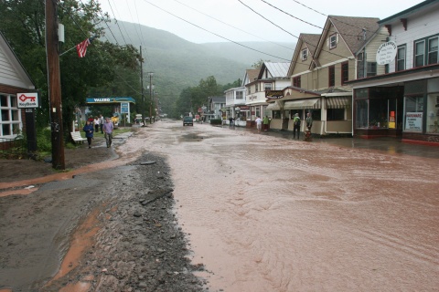
9pm Sunday 8/28/11: Blake Killin took some photos of the devastation in Phoenicia this afternoon and posted them on Facebook:
We're hearing from Watershed Post correspondent Aaron Bennett that there was a landslide along Oliverea Road in Shandaken. From our Hurricane Irene Catskills liveblog:
Aaron Bennett: Just heard from my brother in law who is in the Pine Hill FD that Route 28 is compromised in at least 5 locations making travel to/from Kingston impossible. There was also a significant slide along Oliverea Road (just north of McKenley Hollow). Hatchery Hollow bridge is also only passable by four wheeler (Ulster Co Rte 47 between Big Indian and Oliverea.
Aaron Bennett: Frost Valley Rd/Oliverea Rd. also has a bridge out at the Emu Farm and the waterfall corner is under water. Consider Route 47 impassible from the south.
Aaron Bennett: Slide was around Puckihuddle I heard - was the old Oliverea Post Office - that is about 1 mile downstream (north) of the Full Moon
It seems that landlines are down in the Oliverea area -- people are hoping for updates from the Full Moon Resort and Cold Spring Lodge.
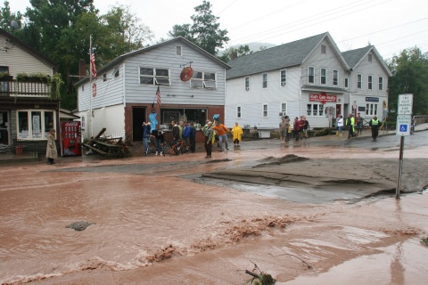
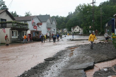
Earlier this afternoon, Kathleen Nolan reported an update about the state of Phoenicia:
Power is out in Shandaken from Mt. Pleasant to Big Indian. Phone service intermittent. Phone and power service in Pine Hill. A section of the south side of Route 28 just east of the Portal has washed into the Esopus - only one lane open there. The shoulder of Route 28 just east of the bridge on Route 28 in Mt. Pleasant was swept up and folded over, overturning 3-4 cars and buckling the pavement. State of emergency continues, so only rescue vehicles and emergency vehicles on the road. Water rescue apparently being started for people who remained in Rock Cut cabins. Earlier water rescue attempt in Fox Hollow could not be completed due to high water velocities. No word on status of people unable to evacuate Fox Hollow. Very bad everywhere in Shandaken, although waters are beginning to recede somewhat as the rain slackens.

5pm: We're hearing reports that multiple bridges in Shandaken are out, including on in Mount Tremper. Here's the latest from Tom Rinaldo, our correspondent:
Lissa Harris:
Another report from Tom Rinaldo in Phoenicia, who drove up 214 towards Tannersville just now to see how far he could get:"On 214, the damage we were seeing was on the shoulders. The shoulders are in pieces. But the road is in better shape than I'd expected. I made it all the way from Phoenicia to Notch Hill Road, and I turned around at that point because there was a section that water was running across. I didn't want to take any chances.
Chances are good you could get as far as Tannersville.
At one point near Willa Road, water was crossing, about 6 inches deep. And at a private road called Grubman, there is a logging road on the other side, there was a major old bridge which has totally collapsed into the Stony Clove.
As I was coming down off Wright Road, I looked off to the side, there was another bridge across the Stony Clove that's totally down. There might be more.
The RVs in the Black Bear Campground weren't carried away, but they were moved.
The Empire State Railway Museum had water running through it.
The water is receding quickly in town now."
On the presumed Lanesville drowning, which Tom told us about last time we spoke:
"Ernie at the Fire Dept, whose last name I can't remember -- he might be the vice president of the hose company -- he told me that there was a witnessed loss of a person, an elderly man, who fell in and couldn't be reached. But he didn't see it personally. That's the authority I have it on."
3pm: The Esopus Creek has crested at a new record, according to the above hydrograph, at 23.34 feet. Our Phoenicia correspondent Tom Rinaldo just got through to us at Watershed Post HQ with a detailed report of Phoenicia's status:
Lissa Harris: On the phone with Tom Rinaldo in Phoenicia. Eyewitness account, reporting from across the street from the fire dept.:
"About 15 minutes ago the fire dept got a call saying we're in the eye of the storm. The water is going down. The main bridge over the Esopus has some serious damage. The bridge over the Stony Clove is being examined to see what kind of shape it's in -- it's not obviously unusable but may be structurally unsound.
Boulders were going down the river, cracking against each other. It was the eeriest sound.
Main Street is probably going to come out OK. It's probably going to be passable. There's a stream still going over it but it's receding.
The propane tanks behind Sweet Sue's are now in front of the Catholic Church. There's a park bench near Brio's that probably came from 214. They were using a backhoe to dredge sand off the street.
Heading up towards Hunter on 214, you can see slabs of the road at angles, pieces of it are up. Some of the firemen saw the river flowing down the road pulling up pieces of pavement. At one point every bridge between Main Street and Tannersville/Hunter was overtopped with water.
Ernie from the Fire Dept. said the Esopus got up to 23 feet. The most he's ever seen was 19.20, and he's been there 20 years.
If you stand at Mama's Boy and look across to Brio's, behind Brio's, that whole north side of main street, behind the buildings, is a river. It's a new river. You'd think you were looking at the Esopus.
North of the Fire Department, somewhere north of the Cobblestone Motel, the Stony Clove jumped its banks. It's all that water, I think, that is causing the stream behind Brio's.
On 214, near the Cobblestone Motel: There are telephone poles, electric poles falling down. About 60 degrees off, leaning down towards the road, and the wires on those poles are about six feet off the ground.
There's a confirmed death in Lanesville. An elderly man was trying to clear some stuff off where the stream was and fell in. There were two witnesses. There were a couple of houses that got destroyed in Lanesville.
There was a rescue attempt west of Phoenicia on 28, on the left hand side, about four miles, there were some people stranded, the water had risen to the second floor. Mount Whitney has the normal rescue unit, but it couldn't get out of town because the bridges were impassable. They transferred the call to the Shandaken fire dept., and that's the last we know about that.
The lower-lying areas of Phoenicia, there was a mandatory evacuation. Whether anyone policed that to make sure everyone left -- I suspect they don't have the resources to force everyone out. That includes the trailer park, parts of Jay Street, High Street. We don't know what's going on over there."
THANK YOU, TOM.
11am: According to the hydrograph above, the Esopus Creek is now above 19 feet. At 18 feet, roads and bridges are washed out. The river is now expected to crest at 21 feet, which is the height at which Rte. 28 and Boiceville are covered with water.
10:45am: We're trying to get information about Phoenicia, but there is no answer at either Shandaken Town Hall or, disturbingly, at Ulster County Emergency Communications. Our internet service provider here in Andes is predicted to soon go out, so we may soon be radio silent as well.
10:10am: Here's the 9am email alert from Ulster County Emergency Communications Manager Art Snyder:
Several towns have issued States of Emergency. Joining previously declared
towns are Gardiner, Ulster, Wawarsing and Ellenville.Numerous evacuations, as well as rescues are taking place.
Roads are closed across the County.
The Advanced Hydrologic Prediction Service projects that most streams in
Ulster will go to major or even record flood stages. Flood warnings have
been issued for all major bodies of water.Power outages will be a huge problem for some time. At this moment there
are approximately 40,000 of 93,000 Central Hudson and NYSAC customers are
without power. Extreme caution must be used due to the number of downed
trees and wires.
8:30am: A state of emergency was declared in Shandaken at 6am this morning, according to the Town of Shandaken's Facebook page, and residents are being asked to voluntarily evacuate to higher ground.
We just spoke with coordinators at Shandaken's Town Hall. According to Mark Bedell, all side roads in Phoenicia are closed. Residents are being urgently told to evacuate, if they can get to Route 28 safely. Route 28 is still open as of 8am.
Bedell says that a rescue is currently in progress at Deer Lane in Big Indian.
The Esopus Creek has reached flood stage and has begun to close roads -- flooding es expected to reach 20 feet, according to the latest hydrograph. At that level, water is licking at Route 28.
Bedell says that water began flooding Main Street Phoenicia at about 7am and is now coming through the parking lot of Shandaken's town hall along Route 28.
Tom Rinaldo, our man in Shandaken, reported at 7:20am that one person had already been rescued from rising waters in Big Indian, and that people who want to evacuate to the shelter at Belleayre Ski Center must do so as soon as possible:
Just was told by an officer of the M. F. Whitney Fire Dept in Phoenicia that if we wanted to leave town, now was the time to do it. Water levels in (I believe the Esopus) have risen two feet in the last half hour. Phoenicia seems headed to being cut off hopefully only until the waters recede. Right now passage is still clear.
Also told by volunteer fireman that a rescue was just done of person or people trapped in a house in Big Indian with water starting to flow around it.
Here's Shandaken's warning to residents from its Facebook page:
Town of Shandaken 6:00am - Sun., Aug. 28 - STATE OF EMERGENCY DECLARED! Town of Shandaken is under severe threat from Hurricane Irene. Water levels are rising rapidly due to saturated soils. The Esopus Creek Gauge at Cold Brook has reached flood stage and will continue to rise. Please be advised that emergency crews will be visiting all flood prone areas and asking that they seek shelter to higher ground. Belleayre Mountain (Upper) Overlook lodge is available to all.
7:15am - Sun., Aug. 28 - ROAD CLOSINGS! The following roads are closed or closing: Plank Rd., Main St., High St., Station Rd., Woodland Valley Rd.-Phoenicia; Rte. 214-Chichester; Fox Hollow Rd., Shandaken; Oliverea Rd., Deer Ln., McKenley Hollow, Lost Clove Rd., Lasher Rd. - Big Indian. Please be advised not to drive through water on roads. Waters contain hidden dangers. If you need assistance please call Town Hall at 688-7165.
Phoenicians and Shandaken residents, please keep us updated on what you see. Email photos and videos updates to [email protected], submit updates to our liveblog, or message us on Facebook.


