


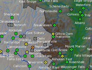
Screenshot of river flooding forecasts for the next 48 hours, via the NWS Hydrological Prediction Services website. Only the Pepacton Reservoir is forecast to flood.
Worries that storms are heading our way tonight have been pinging around the Catskills, online and off.
At 2pm today, the National Weather Service issued forecasts predicting strong thunderstorms and heavy rains in some of the areas already hard-hit by flooding from Hurriance Irene last week. The forecast calls for possible gusty winds and heavy rainfall tonight in Hunter, Tannersville, and Windham in Greene County; Middleburgh and Cobleskill in Schoharie County; and Woodstock, Ellenville, West Hurley, Phoenicia, Kingston, New Paltz, and more towns in Ulster County.
The Ulster County Emergency Communcations HQ issued a somewhat reassuring assessment of the situation at 1pm today:
Special attention to those working on recovery efforts from Irene
Here is a synopsis of today's call with the National Weather Service: Storms will be more organized later this afternoon and tonight (especially north of Albany). Flash flood information has not changed since yesterday. A flash flood watch is in effect in areas north and west of Albany from 2 PM this afternoon until 8 AM Tuesday morning. Things are somewhat improved for the river flooding forecast. There will be general precipitation tomorrow, but it now appears a large area of heavy rain will shift to our east. Therefore we will still get rain on Monday, but not the real heavy precipitation. Tuesday should dry out. Overall model guidance indicates about 1-2 inches of rain as a basin average (more in thunderstorms). This is less than yesterday. Additional precipitation from the remnants of Lee should not be seen until the Wednesday time frame.
Arthur R. Snyder Ulster County Emergency Communications/Emergency Management
The good news is that according to the NWS's Advanced Hydrological Prediction Service, the only river/reservoir in the Catskills that is expected to flood in the next 48 hours is the Pepacton Reservior. Check out the region-wide interactive map of river gauges -- map locations in orange are where flooding is expected.


